3D concepts of shared lane markings. Source: NACTO's Urban Bikeways Design Guide
These days, sharrows can’t get no respect. And cyclists who have been grumbling about them for years have some new ammo in a recently published research study, which concludes that sharrows are relatively ineffective at encouraging bicycling and keeping cyclists safe. But are they really “the dregs of bike infrastructure—the scraps cities hand out when they can’t muster the will to implement exclusive space for bicycling”? Because wow! That’s… something…! So let’s take a closer look at what sharrows are, interrogate the hate and come to some sort of reasoned understanding of their place (or not) in a traffic engineer’s bag of tricks. First:
What (the heck!?) are sharrows?
To fanfare from bicycle advocates nationwide, the FHWA added Shared Lane Markings (aka “Sharrows”, or “share the road + arrows”) to its 2009 edition of the Manual on Uniform Traffic Control Devises (MUTCD). By providing specific guidance regarding these markings, sharrows became a legit option for traffic engineers seeking to design roadways more accommodating of cyclists—particularly where there was no space for separated infrastructure. The use of sharrows soon exploded in cities throughout the United States; Columbus received its first sharrow on High Street near OSU in May 2010. There are now approximately 81 miles of sharrows in the Mid-Ohio Regional Planning Commission's Metropolitan Planning Organization area.

The unveiling of Columbus' first sharrow, in 2010. Source: ColumbusUnderground.com
According to the MUTCD, sharrows are intended to:
“A Assist bicyclists with lateral positioning in a shared lane with on-street parallel parking in order to reduce the chance of a bicyclist’s impacting the open door of a parked vehicle,
B Assist bicyclists with lateral positioning in lanes that are too narrow for a motor vehicle and a bicycle to travel side by side within the same traffic lane,
C Alert road users of the lateral location bicyclists are likely to occupy within the traveled way,
D Encourage safe passing of bicyclists by motorists, and
E Reduce the incidence of wrong-way bicycling.”
NACTO's Urban Bikeway Design Guide provides a more in-depth take on sharrows and how they are to be used.
Sharrow hate: what’s up with that?
Point taken: a cyclist who clearly does not understand what that sharrow is for (i.e., to help him position himself correctly in the lane). Source: dispatch.com.
Six years on, some very vocal cyclists nationwide are disgusted by the sharrow (like, seriously). Complaints include that no one seems to know what they mean, that they've often been poorly placed, that they offer no real protection from cars, that they may suggest to drivers that roads without them aren't meant for cyclists, that they seduce inexperienced cyclists onto roads too challenging for them... in a nutshell: sharrows suck because they're not protected bike lanes. And further: government officials suck because they wuss out and install sharrows instead of protected bike lanes.
A place for sharrows?

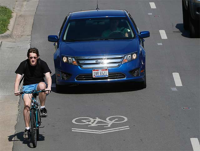
The sharrow, or “Shared Lane Marking”, as defined in the Manual on Uniform Traffic Control Devices.
We at Yay Bikes! tend to go all side-eyed on anything that smacks of a we-should-have-protected-bike-lanes-from-my-doorstep-to-infinity argument. Because seriously guys—we're bright-eyed dreamers as much as anyone, but it's NOT HAPPENING and probably shouldn't. Still, is it responsible for a bicycle advocacy organization to bless sharrows? Or, given the critiques above, should we always hold out for more?
The research on sharrows is not so bleak as the new study would suggest. Sharrows have been found to reduce the incidence of sidewalk riding, encourage cyclists to ride in the proper lane position, increase the distance between cyclists and parked cars, encourage safe passing and reduce the incidence of wrong-way riding (click the link and scroll to Shared Lane Marking Benefits for research supporting these findings). The impact isn't as significant as it is with bike lanes, but it's not nothing either. Certainly sharrows aren't more dangerous than nothing at all!
In the study referenced above, called "Relative (In)Effectiveness of Bicycle Sharrows on Ridership and Safety Outcomes", researchers Nick Ferenchak and Wesley Marshall of the University of Colorado Denver compared rates of bike commuting and cycling injuries within census blocks in Chicago before and after bike lanes and sharrows were added, as well as blocks where nothing was done to the streets. What they found was that: 1) rates of bike commuting increased more than 109% on streets with bike lanes, 43% on streets with no change and just 27% on streets with sharrows, and that 2) rates of cycling injury decreased 42% on streets with bike lanes, 37% on streets with no change and 20% on streets with sharrows. They conclude: "It is imperative that the appropriate infrastructure and treatments are in place to ensure the safety of all users on our roadways, and it may be that sharrows do not have a role to play in this pursuit." Yikes!
But again—are sharrows really worse than nothing?!?! Doubtful. The study authors reveal assumptions that should give us serious pause. In particular, because their analysis takes place on the census block group level, they admit that they can’t account for how much infrastructure was installed, or where (i.e., was it on one corridor or throughout?). In fact, we have no information about the types of streets under consideration or the extent of the accommodations. It stands to reason that if lots of very busy streets with high rates of crashes get bike lanes, there will be a more dramatic decrease in injuries than there would be on slower streets that receive sharrows. Further, the authors admit that the presence of bicycle commuters living in a census group does not translate to bicycle exposure (i.e., how often these bicycle commuters actually ride the roads, or where). We don't know the actual number of cyclists who were riding on these streets during the timeframe for analysis. At all. Which would seem to be a critical detail if you're seeking the overall rate of cycling, yeah?! So, not to knock the study altogether, but unless we see something rather more convincing...
Our bottom line re: sharrows
You can count on Yay Bikes! to advocate context sensitive solutions that make the best of the roads we've got today, always with an eye towards making them better tomorrow. And we strongly believe that, while sharrows aren't perfect (what bike infrastructure is?), they have an important role to play in (literally and figuratively) moving us from here to there. So where it makes sense, we will bless them, yes, and absolve traffic engineers who decide they're the best possible option given the constraints at hand. Because sometimes they really are the best possible solution for a particular roadway—like when they're placed in the center of lanes too narrow to share or accommodate bike lanes. Of course, regardless of whether it’s sharrows or protected lanes or something else, we advocates must help engineers ensure it is carefully installed. And we must help both cyclists and motorists understand a cyclist's proper lane position relative to the new road design. This is what Yay Bikes! promises to do, with your help.